The Kurdistan Region’s Bahdinan Gate, survivor of centuries

ERBIL (Kurdistan 24) – Upon visiting Duhok province, one isn’t likely to miss Amedi (Amadiya), one of the historic towns of the Kurdistan Region with the richest history. It is perched on a mesa and was once the capital of a very powerful semi-autonomous Kurdish principality.
The mountaintop town of modern-day Amedi remains a shining and characteristic example of Kurdistan’s natural beauty.
During the Bahdinan Empire, founded in the 13th Century, there were two main gates in Amedi; Zebar gate located to the east of the town and Bahdinan Gate to the west.
It is known that both gates stood open during the daytime and closed at night, but there are gaps in the historical record, which includes some documentation of outsiders seeing them for the first time.
French citizen Henry Bernier documented having visited the gate in 1885, describing it as “an iron gate adorned with arabesque carvings.”
Kurdistan 24 spoke to Kovan Ehsan Yaseen, an archeologist who has been following as closely as possible to the full spectrum of history and archeology in Amedi as part of efforts to learn more about the remarkable gates.
“The Zabar Gate led to several routes, but the main route was to the east to the Kalya stone bridge, close to Rashava valley, and from there forward to the Barzan area,” he said.

Other routes, he explained, ran to Sherana valley and on to Zebari tribal areas, as well as another route to Derashi village and then to Kafia village and on to Akre.
“This one is a very historic route. In 1903, this exact route was used by English traveler Mark Sykes to go to Akre. Sykes would later have the infamous Sykes-Picot Agreement, in which the UK and France split up the Middle East after World War I, named after him.
The gate existed in its near-original form until 1938, when it was destroyed as part of construction on a new road leading into the town of Amedi. It left only a few scattered ruins surviving in place, with the moveable part of the gate being moved to the Baghdad Museum, where it remains today, said Yaseen.
Beneath the gateway are the remains of a tunnel that was used by ancient Kurdish royalty in emergencies. The passage used to lead to a palace in Amedi, uncovered in construction but reclosed as another road was built.
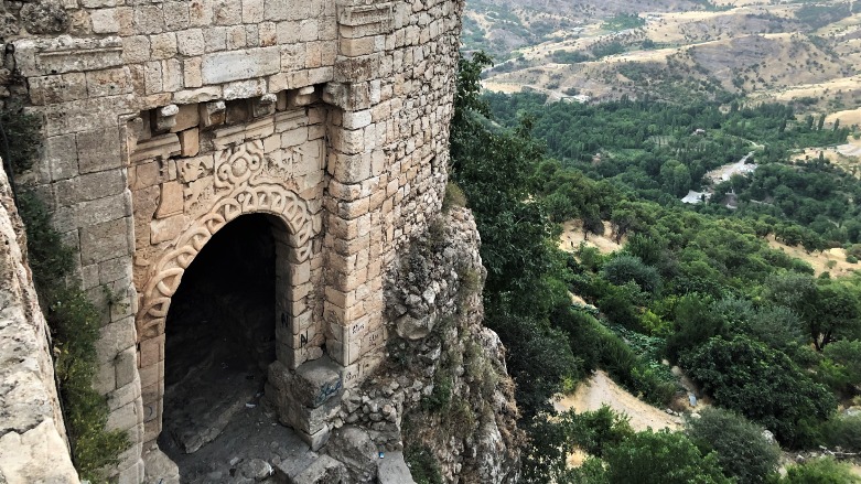
Sitting atop the western slopes of Amedi is Bahdinan Gate, also known over the years as Mosul Gate, Saqava Gate, or Sipna Gate.
German professor Walter Bachmann took a photo of it in 1911 which he later released in 1927.

The arched stone gate was the main entrance into the fortified town, once the capital of the Kurdish Bahdinan Empire, but there is no clear record of the structure’s origins.
Writing on the gate itself dates it at least as far back to the leadership of Badr al-Din Lu Lu, who ruled from 1234 to 1259 as successor to the Zengid emirs of Mosul, but the history of the unique gate is thought to begin far before that date.
Three relief sculptures found nearby also date back to the 2nd Century.
The gate and the road it sprang from served a strategic purpose, connecting the capital of the Bahdinan Empire to the city of Mosul.
It was also used for diplomacy and trade with the outside world especially with Mosul, Baghdad, and Istanbul, during the reign of Sultan Hussein Wali (Khan).
Equivalents to the modern hotel were constructed along the road as far as Mosul including around the villages of Qadish, Aradina, Tazhika, and Kora, as well those in what is now Duhok and Telskuf, demonstrating how important a road it was.

Although Mosul and Bahdinan had close ties, at the same time, forces from Mosul would periodically attack Amedi when the economy in their city took a downturn. The last time this occurred, it was ordered by Mosul Governor Mohammed Inga Bayraqdar in 1842, leading to the fall of the Bahdinan Empire as one of the most powerful and enduring of ancient Kurdish principalities.
On top of the gate is an engraving of the sun with 36 rays emanating from it, although it is a mystery to modern scholarship as to what the specific number of rays might signify.
There are also engravings of two intertwined snakes in front of two warriors. Since the gate was the first thing travelers would see as they approached, the design is thought to indicate a warning of power and strength.
The gate’s stairway leads to a water source known as Lawlab Spring, one of the original sources of water used by the town’s residents.
Photos from 1911 and 1922 suggest some renovation of the gate being carried out at the time, but no details have survived. In 1981, the Iraqi antiquities authority renovated the gate, though it, unfortunately, led to some harm to its original structure. In 1998, it was again worked on in a way that caused further damage. A current effort for a more archeologically-based reconstruction has been budgeted but has yet to begin.
Now, Amedi district is famous for having many tourist destinations, primary among them the legendary Bahdinan Gate that has endured long past the original cultures that built it.
Editing by John J. Catherine