Kurdish Developer Unveils AI-Powered 3D Mapping App for the Kurdistan Region
A locally developed mapping platform combines artificial intelligence, 3D visualization and rebuilt geographic data to deliver navigation tailored to the Kurdistan Region.
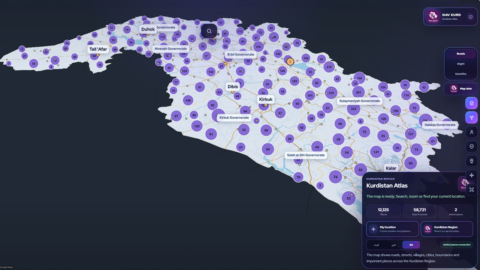
ERBIL (Kurdistan24) - As digital maps have become indispensable for everyday travel, commerce and public services, one Kurdish software developer is pursuing a different approach, building a navigation platform designed specifically around the geography, communities and needs of the Kurdistan Region.
Developed by Sarhang Salah, the new application combines 3D mapping, artificial intelligence and GPS technology to create a localized digital navigation system that extends beyond conventional route guidance.
Rather than competing through global scale, the project focuses on regional specialization, aiming to provide geographic information and digital services tailored to users across the Kurdistan Region.
Speaking to Kurdistan24, Salah said the platform was developed using several programming languages, including Java and TypeScript alongside HTML and CSS, while artificial intelligence played a central role in organizing the application's underlying structure.

According to the developer, AI is used to improve the accuracy of mapping data, streamline information management, reduce software errors and reinforce system security.
The technology also supports privacy-conscious design by helping maintain the integrity of user data while enhancing the platform's overall performance.
Those technical foundations underpin a broader effort to create a mapping service that reflects local realities. Unlike international platforms built to cover virtually every corner of the world, Salah's application concentrates exclusively on the Kurdistan Region, allowing greater attention to regional geographic detail and locally relevant services.

Among its distinguishing features is an extensive rebuilding of the application's place-name database.
Salah explained that he reorganized the geographic information using his own database architecture, restoring Kurdish place names and restructuring regional mapping data within the platform.
He presented the initiative as an effort to create a locally focused geographic reference system as part of the application's overall design.
Beyond its underlying data, the platform incorporates a range of interactive tools intended to make navigation more responsive to everyday users.

Registered account holders can personalize their experience, add business listings, upload photographs and organize locations using customized icons, creating a more community-driven mapping environment.
Navigation itself is supported through a real-time GPS system that continuously updates according to a user's position and direction of travel.
The application recommends routes based on different modes of transportation, generating separate guidance and estimated arrival times for motorists, cyclists and pedestrians. Integrated weather information further allows users to check conditions at their destination before setting out.

Taken together, those features reflect a broader trend in software development that places increasing emphasis on localized digital services rather than one-size-fits-all platforms.
By combining geographic specialization with emerging technologies such as artificial intelligence and 3D visualization, the project illustrates how regional developers are adapting global innovations to meet local needs.
The application also highlights the expanding capabilities of Kurdistan's technology community, where developers are increasingly creating software designed around the Region's own infrastructure, businesses and users instead of relying exclusively on international digital ecosystems.

Salah acknowledged that the platform remains in an early stage of development but said additional support and investment would enable further expansion and the introduction of more advanced capabilities in the future.
Whether through improved mapping accuracy, interactive business information or AI-assisted data management, the project demonstrates how locally developed software can address regional challenges with solutions built from the ground up.
As digital infrastructure becomes an increasingly important part of daily life, initiatives such as this suggest that innovation within the Kurdistan Region is evolving beyond software adoption toward the creation of homegrown technologies designed for local communities.

|
Summary A Kurdish software developer has introduced a 3D mapping platform built exclusively for the Kurdistan Region, combining artificial intelligence, GPS navigation, rebuilt local geographic data and interactive community features to demonstrate the growing strength of locally developed digital innovation. |
Kurdistan24 journalist and news writer Lavin Omar contributed to this report.