Kurdistan Region Braces for First Heavy Snows and Widespread Rainfall as Winter Descends
Winter hits Kurdistan with heavy snow in mountains and rain in cities; Soran drops to 8°C while Garmian hits 15°C as the 48-hour weather wave peaks.
ERBIL (Kurdistan24) – As the calendar pivots to mid-December, a distinct and formidable atmospheric shift has descended upon the Kurdistan Region, heralding the definitive arrival of the winter season with a convergence of low-pressure systems that promise to reshape the landscape over the next 48 hours.
Meteorological authorities have confirmed that a new wave of weather instability has reached the area, bringing with it a complex mix of moderate rain, atmospheric dust, and, most significantly, the season's first heavy snowfall across the high mountains and border regions.
This meteorological event marks a critical transition point for the geography of the Kurdistan Region, transforming it into an arena where blue skies surrender to dense cloud cover and the thirsty earth is finally quenched by a sustained deluge, signaling the opening of what experts describe as the traditional gateway for the entry of intense cold and radical climatic changes.
The onset of this system on Friday, December 12, 2025, has introduced an immediate alteration to daily life across the cities and rural hinterlands alike.
According to the latest forecasts, the skies over the major urban centers have been completely blanketed by clouds, ending a period of relative stability. However, the situation is not limited to mere overcast conditions; rather, a pattern of drizzle and moderate rain has begun to intermittently cover most areas, washing over the plains and valleys.
Simultaneously, a layer of dust has been observed covering parts of the cities, adding a texture of grit to the incoming moisture.
This combination of rain and dust serves as the prelude to a much colder front, with temperatures recorded on Friday dropping by 1 to 2 degrees Celsius compared to the preceding days, a tangible indicator that the warmth of autumn has finally dissipated.
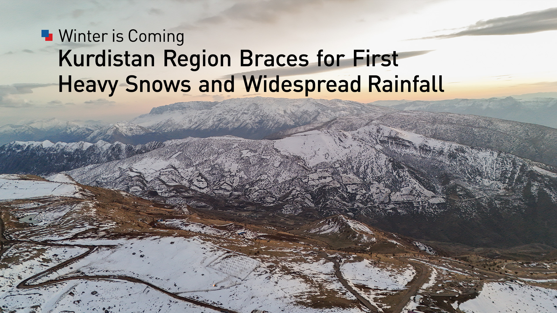
While the cities experience the damp chill of rain, the high mountainous areas and border regions are witnessing a far more dramatic transformation.
For the first time this season, heavy snow is whitening the peaks, altering the visual and physical character of the region’s topography. This snowfall is not merely a weather event but a seasonal milestone, visually confirming the onset of the winter season in the Kurdistan Region.
The arrival of the snow is accompanied by shifts in wind dynamics, with speeds ranging between 10 and 20 kilometers per hour. These conditions have had a measurable impact on navigational clarity, with visibility decreasing to a range of 6 to 8 kilometers, necessitating caution for travelers navigating the winding mountain roads that connect the region's districts.
The implications of this weather system extend far beyond the immediate inconvenience of wet streets and cold winds. This wave is viewed as being of immense strategic importance for the environmental health and agricultural sustainability of Kurdistan.
The precipitation currently falling is critical for enriching groundwater levels, which have been depleted during the drier months. For the farming communities that form the backbone of the region's rural economy, this rain represents a vital resource, quenching the soil and preparing the land for the coming agricultural cycles.
Furthermore, the aesthetic transformation of the mountains into snow-capped peaks lends a "magical scenery" to the area, a phenomenon that is eagerly anticipated annually by tourists and locals alike who flock to the highlands to witness the winter spectacle.
The effects of this atmospheric instability are projected to persist and evolve as the weekend progresses. Forecasts indicate that the conditions observed on Friday will continue into tomorrow, Saturday, December 13, 2025.
The early hours of Saturday are expected to remain dominated by cloudy skies, with rainfall continuing to drench most areas. In the border regions, the snow will continue to fall, deepening the accumulation on the high ground.
However, meteorologists predict that this specific wave of rain and snow will not be prolonged indefinitely.
The system is expected to taper off and conclude by Saturday night, leaving behind a chilled and altered landscape. Even as the precipitation ceases, temperatures will remain at a low level, maintained by continuing southeasterly winds, while the sky is expected to transition to a partly cloudy state.
The temperature gradients predicted for Saturday highlight the diverse climatic zones within the Kurdistan Region. Soran is forecast to be the coldest area, with a high of only 8 degrees Celsius, reflecting its elevation and proximity to the snow line. In stark contrast, the Garmian administration is expected to be the hottest area, reaching 15 degrees Celsius.
The capital, Erbil, along with Sulaimani and Halabja, are all predicted to see highs of 13 degrees, while the northern cities of Duhok and Zakho are expected to reach 14 degrees. Kirkuk is forecast to match Garmian’s 15 degrees, while the mountainous towns of Akre and Amedi will see temperatures of 13 and 10 degrees, respectively.
As the second half of December begins, this weather event serves as a reminder of the region’s dynamic geography.
The convergence of low-pressure systems has effectively opened the door to winter, bringing the cold, the rain, and the snow that are essential for the renewal of the land's resources. For the next 48 hours, the Kurdistan Region will remain under the influence of these elements, as the mountains turn white and the valleys drink their fill, setting the stage for the months of cold that lie ahead.
This new weather forecast follows a period of heavy rainfall that severely disrupted daily life in the Kurdistan Region, causing extensive damage to homes, infrastructure, and agricultural assets, and resulting in five confirmed fatalities.
Recent torrential rains and flash floods across the Kurdistan Region have caused widespread destruction, particularly in Sulaimani province, Garmiyan, Chamchamal, and pockets of Erbil and Duhok.
Heavy downpours earlier in the week triggered sudden flooding that destroyed more than 200 fish farms in Erbil’s Taqtaq district, wiping out over 800,000 fish and damaging essential agricultural equipment, public parks, and private gardens.
The disaster inflicted extensive damage on homes and local infrastructure, with preliminary estimates indicating that around 150 houses were affected in Garmiyan alone, while Chamchamal District reported damage to approximately 500 homes and more than 100 shops.
The severe weather also disrupted major road networks—such as Sulaimani-Chamchamal, Kirkuk-Baghdad, Kalar-Rizgari, and Kifri-Rizgari—isolating communities and straining emergency response capacity.
Despite the destruction, the heavy rains delivered a measurable boost to the region’s water reserves.
Officials reported that the Kurdistan Region captured roughly 250 million cubic meters of water, contributing to a broader nationwide increase of 700 million cubic meters in Iraq’s overall reservoirs.
Lakes, dams, and groundwater sources saw significant replenishment, easing long-term concerns over summer water shortages.
Snowfall in Soran, Sidekan, and other high-altitude areas compounded the disruption, triggering landslides, blocking border crossings, and halting trade and travel.
In response, the Kurdistan Regional Government (KRG) has mobilized a comprehensive emergency effort. Prime Minister Masrour Barzani ordered immediate assistance to flood-affected communities and rapid reconstruction of damaged infrastructure, including nearly 40 schools in Chamchamal.
Compensation committees, crisis-response units, and civil defense teams have been deployed across all affected administrations; water-treatment facilities have implemented temporary shutdowns due to high turbidity, with officials urging the public to conserve water.
Charitable organizations—including the Barzani Charity Foundation and the Kurdistan Foundation—have sent aid convoys, distributed supplies, and established temporary shelters for displaced families.
As cleanup operations continue and damage assessments expand, the region is now transitioning from immediate disaster response to medium-term recovery, setting the stage for close monitoring of the upcoming 48-hour weather outlook and its implications for a heavily impacted population.